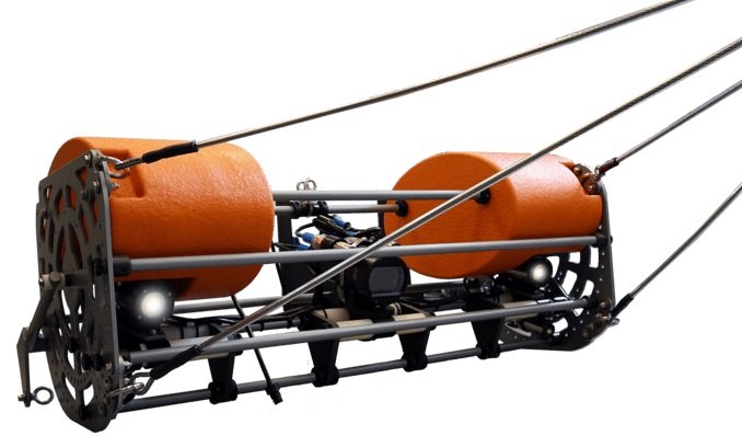
SubC Imaging Upgrades Tow Camera System
SubC Imaging has updated its Tow Camera System with significant upgrades in both hardware and software to meet the changing demands of underwater surveys and research. This new version builds on the proven success of the original system, incorporating cutting-edge features designed to improve operational efficiency, data quality, and user experience.
Enhanced Hardware for Precision and Ease of Use
The updated Tow Camera System boasts several hardware improvements to achieve more precise and detailed underwater footage. New adjustable LEDs, lasers, and camera settings provide customizable illumination, measurement, and capture options, allowing users to fine-tune the system to their specific needs. These enhancements ensure superior footage quality and accuracy, making the system ideal for seafloor mapping, marine observations, and infrastructure inspections.
Safety has been enhanced, making the system even more reliable in demanding subsea environments. User-friendly improvements have been introduced to simplify adjustments in the field, ensuring that the Tow Camera System is easy to deploy and operate.
New Software Upgrades for Real-Time Insights
The Tow Camera System is now powered by Rayfin Single Channel Inspection Software, offering real-time media and data transfer. Users can instantly access and record data topside, without post-mission downloading, drastically reducing post-processing time. Automated organization and embedded metadata streamline the retrieval and analysis of images, videos, and sensor data, while new capabilities such as Rapid Digital Imaging (RDI) allow for high-resolution stills capture and LED strobing at speeds of up to 2Hz.
New software features:
Real-Time Data Transfer: Provides immediate access to media and data without delays.
High-Quality Live Viewing and Capture: Streams HD and 4K video while simultaneously capturing 12MP stills, ensuring high-quality detail.
Built-in DVR with Overlays, Annotations, and Voiceover: Record videos with overlays, annotations, and voiceovers, enhancing documentation and facilitating detailed analysis and sharing of findings.
Comprehensive Data Management: Automatically logs data with embedded timestamps, sensor information, and other critical metadata, enhancing the traceability and integrity of collected information.
Integrated Control and Visualization: The system provides integrated control over the camera, LEDs, and lasers - all in one interface.
Pushing Boundaries in Underwater Technology
The upgraded Tow Camera System can operate at depths up to 380 meters. Built for the most challenging underwater conditions, the system’s rugged stainless steel and epoxy-coated aluminum frame ensures durability, while its neutral buoyancy design provides optimal stability during tow operations.
“The latest version of our Tow Camera System sets a new standard in underwater imaging,” says Chad Collett, CEO of SubC Imaging. “We’ve incorporated feedback from our customers and pushed the boundaries of what’s possible in data acquisition, usability, and imaging quality. This system will empower research and inspection professionals to capture the highest-quality visual data in real-time, drastically improving the efficiency of their operations.”
Summary of Key Enhancements
Improved Deployment & Setup: Pre-assembled, field-adjustable design simplifies setup, minimizes downtime, and includes additional safety features for secure and efficient operation
Optimized Camera, LED, and Laser Adjustability: Easier control over camera placement, illumination, and measurement for superior footage quality and accuracy, even in tough conditions.
Advanced Rapid Digital Imaging (RDI): Captures high-resolution stills with LED strobing at speeds up to 2Hz, enabling clearer, more detailed imaging in fast-moving environments.
Instant Data Access & Transfer: Uninterrupted real-time HD and 4K video with simultaneous 12.3MP digital stills, and topside recording. Plus, enhance your findings with the DVR+ Overlay.
Improved Workflow: Automated data logging of timestamps, NMEA, EXIF data, and sensor information for faster post-survey analysis.


